


")

Before I packed up and moved to Baltimore from public transit mecca Portland, Ore., I eyeballed it on a map and discovered it sits nestled between Washington, D.C., and New York City, both places where I’ve used public transportation with ease. So I just assumed Baltimore would offer as hefty a transit system as its East Coast big-city sisters.
I arrived here sans auto and rode the bus for about a year; even after I bought a car, even after I learned my monthly bus pass cost more than the subsidized monthly parking in newfangled Harbor East where I worked. I was dedicated to doing my part for the environment—and wanted to exercise my support of public transit and my colors as a city dweller. But eventually, like many locals, I learned Baltimore’s “Public Transportation Truth.”
Though I truly enjoyed my ride eaves-dropping on strangers’ love lives and med-ical conditions and the southerly “good morning” greeting from drivers when they boarded at switchover (to which riders always responded back, in unison!), even-tually I had to change my ride. Suddenly, my bus, the number 11, began arriving intermittently early, causing me to wait up to 45 minutes—even during morning rush hour—for the next bus. After several weeks, I gave in and rooted for Baltimore’s public transit in my red Honda Fit from the lanes of the JFX, but honestly, it made me sad. I’ve experienced some improve-ments since then, but, admittedly, Baltimore has miles to go before nearing status as a car-free Camelot.
Many believed the defunct Red Line was a step in that direction, but it turned out the $3 billion price tag for the “boon-doggle” project was too much for Gov. Larry Hogan, and it’s now dead on the rails. But for years, supporters have pursued the Red Line project as a kind of Holy Grail, claiming it would be a project that could launch Baltimore on a more progressive transit path.
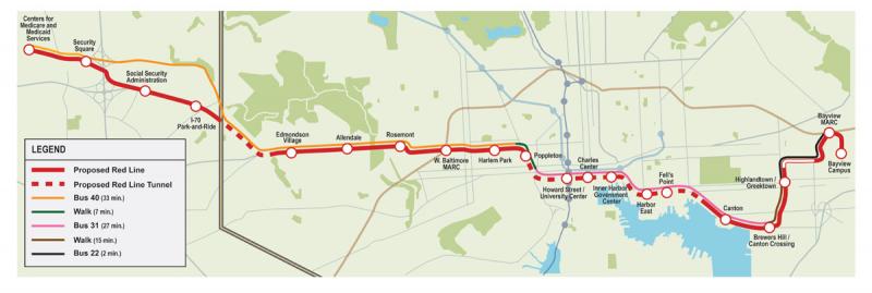
In an effort to understand more, from the street level, about the controversy and kudos following Hogan’s decision, I set out to ride (and walk, where needed) along the entire proposed line. The two underground tunnel sections and one aerial overpass (near Bayview) obviously had to be imagined, but in general, I got a feel for the neighborhoods, riders and commerce that would be served along the path and talked with some people on both sides of the issue.
At 7:33 a.m., bus 22 westbound de-parted the Hopkins Bayview complex in east Baltimore, what would be the eastern most stop on the Red Line. I purchased my day pass for $4, but since I only had a five-dollar bill and the bus machines don’t make change, I “donated” my dollar toward Maryland Transit Authority’s continued improvement.
This raises an interesting point: Light rail riders purchase tickets well before they board a car for transport. So there is no halting a ride, the likes of which can happen on a bus and keep riders queu-ing out the door while someone digs out the exact change, wrestles with a metro card to slide through a machine correctly or asks for directions at a stop.
I exited the bus at 7:35 a.m. at the Grundy and Eastern Avenue stop after passing the “Welcome to Highlandtown” sign on the overpass. The smell of fresh baked goods greeted me, likely from the small family-run bakery across the street. Crossing Eastern and walking back a block to Haven Street, roughly where the Red Line would have gone, I passed a small beauty salon, a man sleeping on a bench, stepped around chunks of busted up sidewalk and walked by a P.O.W. support center. The Walgreens across the street seemed to anchor the intersection.
The walk down Haven was loud but uneventful. I passed a car parts and repair service, a doggie daycare and the Meals on Wheels of Central Maryland facility. The Natty Boh sign winked at me, marking Brewer’s Hill a couple of blocks to the west then the sidewalk ended (there was a sign advertising the Eastern-to-Boston streets resurfacing improve-ment plan, which meant adding a side-walk where none existed), so I continued along on the road where cars and huge semis whizzed past. Both sides of Haven dissolved into a “no man’s land,” with huge, empty fenced-in lots scattered with rubble, old tractors and trucks. Surely a perfect place for high-density housing, had a rail line been added, with a stop at nearby Canton Crossing.
Still on foot, I turned right onto Boston Street and the Target logo quickly came into view, along with other national chains such as Ulta, DSW, Michael’s and a Harris-Teeter. I noticed a long line of cars in the Chick-Fil-A drive through—Baltimoreans craving chicken and biscuits for breakfast—just as I saw my next bus, number 31, leave without me a few blocks ahead. So I crossed the street and opted for an espresso from Dunkin Donuts.
The place was a steady stream of morning regular. The woman in front of me, still in her running clothes, ordered a large iced coffee, with cream and four Splendas. The outdoor seating at Panera was filled with what I can only call “beau-tiful people” of many ethnicities working on laptops. The fast food spots had a constant flow of Baltimore City police officers and city workers picking up breakfast. (The walk from Grundy and Eastern to Canton Crossing took less than 15 minutes by foot, but they felt like two different worlds to me.)
The Right Rail Coalition, made up largely of neighbors from the Canton neighborhood, where I waited for my next bus, was vehemently opposed to the Red Line. RRC formally organized two and half years ago to “advocate for a common sense, reasonable, less expen-sive alternative,” but has been criticized (much like Ruxton was during develop-ment of the north/south light rail line) for basing their opposition on alleged crime that light rail could usher into their neighborhood.
“A statement like that would be defamatory it’s so untrue,” says Ben Rosenberg, vice president of the RRC. “That had absolutely nothing to do with the Right Rail Coalition involvement in any of these transit issues.”
But Ben Groff, a volunteer spokesper-son with Red Line Now, a political action committee that advocated for the Red Line, referenced online comments from residents that used the terms “loot rail” and “crime line.”
Rosenberg says RRC’s opposition is directed at the plan, which they claim is deeply flawed, due foremost to its high cost.
“Henry Kay [the plan’s designer, exec-utive director for transit development and delivery at MTA] said to me last year, ‘You never know what you’re going to encounter [tunneling] until you’re doing it’ and [The Red Line committee] acknowledged tunnel estimates were ridiculously low,” says Rosenberg. “That [proposed] tunnel runs parallel to an existing tunnel, so why would you build a new one? It made no sense.”
RRC came up with an alternative plan that utilizes existing tunnels but also travels well north of Canton and Fells Point to connect with the East Baltimore MARC rail stop, then picks up with the proposed Red Line routing just past downtown at the UMD medical center and continues out to the same terminus.
“Every single public official recognized the efficiencies and improvements that our plan brought to the Red Line and refused to do anything about it,” says Rosenberg, “until I met with [Lt. Gov. Boyd] Rutherford and he saw it immediately.”
Bus 31 at 8:26 a.m. from Canton Cross-ing to just west of downtown took about 27 minutes, compared to the Red Line’s proposed claim of about a 13-minute ride. The bus traced the Red Line route almost exactly along Boston Street, onto Fleet Street then winding up President Street, marinas and condos on the left, upscale restaurants and retail on the right, passing through Fells Point and funky storefronts with smaller homes, then Harbor East in its corporate and retail glory, through downtown past Reginald F. Lewis Museum then onto Lombard past Power Plant Live—but on the Red Line, all of that would be invisible to riders, since it was to travel below ground. I exited at MLK and Saratoga for a quick 7-minute walk to catch the final leg, bus 40.
Buses were comfortably full, not packed, and riders were about 98 percent people of color, with an even mix of gender and ages: small children with par-ents, teens, adults and seniors. From the conversations, I gathered people were going to work or class, shopping or just commuting home. Almost everyone was engaged with an electronic device but some talked to fellow riders. A woman sitting next to me read a Bible; another was killing it on Candy Crush.
A gentleman broadcast (seemingly one-way) conversation on his phone that provided his opportunity to impart philosophical wisdom about parental responsibility to all of us, but his ploy was revealed when his phone rang mid-conversation, yet he didn’t miss a beat. Some teen girls burst into screams when they discovered a bee inside the bus. And a woman begged, quite loudly from the back of the bus, for the driver to let her off anywhere (we were in completely stopped construction traffic) because she had to pee, really, really badly.
At this point, it crossed my mind why light rail was needed where buses already service. “Speed, high capacity, environ-mental impact and reliability,” says Groff.
A single bus holds 50 to 60 people. A single light rail car would hold more than double that. Also, bus reliability is, well, not reliable. “The world is always going to get in the way of a bus,” says Groff, adding that light rail reliability is up in the 90+ percent range.
Besides that, the construction project would have created thousands of jobs for which locals were going to be trained in order to secure those jobs, says Groff. The presence of workers and gainful (even if temporary) employment has proven to have lasting impact on a community by helping families gain financial traction, even after the project has ended.
Bus 40 headed out of downtown and we hit the “highway to nowhere” that is part of Franklin Avenue—passing the West Baltimore MARC stop. As Franklin turns into Edmondson, the vast New Cathedral cemetery came into view. Huddled row houses, some maintained and some boarded up, flanked both sides. We passed a Popeye’s, Kimmy’s Soul Food, Creative Cutz, Family Dollar and a Giant grocery. About a mile down on the left, a huge sign advertised Uplands new home development: urban convenience and suburban charm.
The bus turned right off of Edmond-son onto Cook’s Lane, (another section that would go underground for the Red Line) and we followed Security Boule-vard, replete with car dealerships, discount stores and chain restaurants, then passed Security Square Mall. Wooded areas appeared on both sides, which gave way to a vast sea of cars parked at the Social Security Adminis-tration buildings, then, finally, 34 min-utes after departure, we arrived at the Health and Human Services cul-de-sac where a governmental security check-point greets all entering vehicles. My bus driver said, “I think they do more than Social Security, there’s a lot of Washing-ton, D.C. cars that go in there,” and warned me against taking photos.
From start to finish, including walking time, my Red Line journey was about 85 minutes, compared with what would likely be about 30 to 40 minutes via light rail. With an improvement that sizable, is it just cost holding Baltimore back from progressive transit?
Groff asserts it’s far more: a history of structural racism, a deeply entrenched car culture and a Republican governor’s desire to better serve his constituents.
“Investment in Baltimore is not going to necessarily be a benefit toward a second term for a Republican governor,” says Groff, pointing out that Maryland’s rural and suburban voters trend Republican.
Historically, Baltimore’s proposed Red Line isn’t that different
from any other major city light rail line in that it would connect a city’s disparate neighborhoods and retail areas. And it’s a safe bet that every transit project of this cost and caliber would create some controversy. But what appears more controversial is that Baltimore’s civic leaders currently don’t have an alternate plan to offer its citizens for fast, reliable, safe transit.
So until then, see you on the bus.


